MR-700UB
Product Description
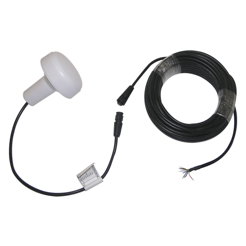
Concinnity and Solid design for GPS Marine Locator with Full Waterproof IPX7
Garmin compatible Marine GPS Receiver
MR-700UB is Marine GPS receiver. Its excellent performance easily conquers the most difficult tasks. In addition , it provides various functions to meet customers' needs.MR-700UB It provides marvelous navigation performance under dynamic conditions in areas with limited sky view like urban canyons.
Product Feature
- u-blox 6 solution
- 50-channel GPS
- SBAS (WAAS, EGNOS, MSAS, GAGAN)
- GALILEO Ready
- A-GPS
- RS232, RS422 interface supported
- 25.0 x 25.0 x 4.0 mm patch antenna
- 7Pin Waterproof connector
- RoHS compliant
- Update Rate 1~5Hz
Possible Application:
- Marine Navigation.
- Fleet Management.
- Mileage Management.
- Tracking devices/system.
- Data logging for marine Navigation.
- Mapping devices for PC & Pocket PC.
- Marine Navigation or touring devices.
- AVL and Location-Based service system.
Product Specification
| Specifications | Parameter | Description |
|---|---|---|
| General | L1 1575.42MHz GALILEO Open Service L1 ublox6 50 channels, C/A code | |
| Sensitivity | -160dBm (tracking) -147dBm (Acquisition/Reacquisition) | |
| Accuracy | Position | 5.0 meters CEP |
| DGPS Accuracy | 2.0 meters CEP | |
| Time | 30 nanosecond rms (1 PPS) | |
| Acquisition | Cold start | 32 sec. (typical) |
| Warm start | 32 sec. (typical) | |
| Hot start | 1 sec. (typical) | |
| Reacquisition | < 1 sec, typical | |
| Dynamics | Altitude | 50,000 meters max. |
| Velocity | 500 meters /sec max. | |
| . | ||
| Operation Temperature | -40°C to +85°C | |
| Storage Temperature | -45°C to +90°C | |
| Operating Humidity | 0% to 95% RH, non condensing | |
| Water Resistance | 100% waterproof | |
| Primary Power | 7V ~ 40V DC | |
| Power Consumption | 150mA | |
| Protocol | NMEA0183 v2.3 | |
| Signal level | RS-232(standard), & RS-422 optional | |
| NMEA Message | GGA, ZDA,GSA,GSV, RMC, VTG(Default) | |
| EMI filter | Rejects power line interference | |
| Power cable | UL 2464/24Awg 15M | |
| Enclosure | High impact, corrosion-proof polycarbonate resin | |
| Connector | Open | |
| Dimensions | GPS Locator | 90.5mm(Dia.) × 108.5mm(H) |
| Mounting Base | 70mm(W) × 41.5mm(H) optional FB1 & FB2 & FB3 | |
| Weight | 200 grams | |
| Standard Mounting | Concinnity and Solid design |
* This specification is subject to change without prior notice
User selectable datum *Pole mount to 1"-14 UNS threaded mast
RS232 I/O Connection
| I/O PIN & CABLE | |
|---|---|
| Wire | Function |
| White | Receive |
| Green | transmit |
| Yellow | N.C |
| Bare Braid | Earth/GND |
| Blue | 1PPS or N.C |
| Purplr | N.C |
| Black | Power- GND |
| Red | Power+ |
RS422 I/O Connection
| Wire | Function |
| White (R+) | Differential input + |
| Green (T-) | Differential output - |
| Yellow (T+) | Differential output + |
| Purplr (R-) | Differential input - |
| Blue | 1PPS or N.C |
| Bare Braid | Earth/GND |
| Black ( - ) | Power- GND |
| Red (+) | Power+ |
Output NMEA Messages
Table 3 NMEA-0183 V2.3 Output Messages
| NMEA Sentence | Description |
|---|---|
| GGA (default) | Global Positioning System Fixed Data |
| GLL | Geographic Position - Latitude/Longitude |
| GSA (default) | GNSS DOP and Active Satellites |
| GSV (default) | GNSS Satellites in View |
| RMC (default) | Recommended Minimum Specific GNSS data |
| VTG (default) | Course Over Ground and Ground Speed |
| ZDA (default) | Time and Date |
GGA--- Global Positioning System Fixed Data
Table 4 contains the values for the following example:
$GPGGA,092725.00,4717.11399,N,00833.91590,E,1,8,1.01,499.6,M,48.0,M,0*5B
Table 4 GGA Data Format
| Name | Example | Units | Description |
|---|---|---|---|
| Message ID | $GPGGA | GGA protocol header | |
| UTC Time | 092725.00 | hhmmss.ss, Current time | |
| Latitude | 4717.11399 | ddmm.mmmmm, Degrees + minutes | |
| N/S Indicator | N | N=north or S=south | |
| Longitude | 00833.91590 | dddmm.mmmmm, Degrees + minutes | |
| E/W Indicator | E | E=east or W=west | |
| Position Fix Indicator | 1 | See table 5 | |
| Satellites Used | 8 | Range 0 to 12 | |
| HDOP | 1.01 | Horizontal Dilution of Precision | |
| MSL Altitude | 499.6 | m | |
| Units | M | meters | Meters (fixed field) |
| Geoid Separation | 48.0 | m | |
| Units | M | meters | Meters (fixed field) |
| Age of Differential Corrections | second | Blank (Null) fields when DGPS is not used | |
| Diff. Ref. Station ID | 0 | ||
| Checksum | *5B | ||
| End of message termination |
Table 5 Position Fix Indicator
| Value | Description |
|---|---|
| 0 | No fix or invalid |
| 1 | Standard GPS (2D/3D) |
| 2 | Differential GPS |
| 6 | Estimated (DR) Fix |
GLL--- Geographic Position – Latitude/Longitude
table 6 contains the values for the following example:
$GPGLL,4717.11364,N,00833.91565,E,092321.00,A,A*60
Table 6 GLL Data Format
| Name | Example | Units | Description |
|---|---|---|---|
| Message ID | $GPGLL | GLL protocol header | |
| Latitude | 4717.11364 | ddmm.mmmmm, Degrees + minutes | |
| N/S Indicator | N | N=north or S=south | |
| Longitude | 00833.91565 | dddmm.mmmmm, Degrees + minutes | |
| E/W Indicator | E | E=east or W=west | |
| UTC Time | 092321.00 | hhmmss.ss, Current time | |
| Status | A | V = Data Invalid / Receiver Warning, A=Data Valid | |
| Status | A | N=No Fix, A=Autonomous GNSS Fix, D=Differential GNSS Fix, E=Estimated/Dead Reckoning Fix | |
| Checksum | *60 | ||
| End of mes End of message termination |
GSA---GNSS DOP and Active Satellites
Table 7 contains the values for the following example:
$GPGSA,A,3,23,29,07,08,09,18,26,28,1.94,1.18,1.54*0D
Table 7 GSA Data Format
NameExampleUnitsDescription
| Message ID | $GPGSA | GSA protocol header | |
| Mode 1 (Smode) | A | See table 8 | |
| Mode 2 (Fix Status) | 3 | See table 9 | |
| Satellite Used | 23 | SV on Channel 1 | |
| Satellite Used | 29 | SV on Channel 2 | |
| Repeated for each channel | |||
| Satellite Used | Sv on Channel 12 | ||
| PDOP | 1.94 | Position Dilution of Precision (00.0 to 99.99) | |
| HDOP | 1.18 | Horizontal Dilution of Precision (00.0 to 99.99) | |
| VDOP | 1.54 | Vertical Dilution of Precision (00.0 to 99.99) | |
| Checksum | *0D | ||
| End of message termination |
Table 8 Mode 1 (Smode)
| Value | Description |
|---|---|
| M | Manual- forced to operate in 2D or 3D mode |
| A | Automatic-allowed to automatically switch 2D/3D |
Table 9 Mode 2 (Fix Status)
| Value | Description |
|---|---|
| 1 | Fix not available |
| 2 | 2D Fix |
| 3 | 3D Fix |
GSV---GNSS Satellites in View
Table 10 contains the values for the following example:
$GPGSV,3,1,10,23,38,230,44,29,71,156,47,07,29,116,41,08,09,081,36*7F
$GPGSV,3,2,10,10,07,189,,05,05,220,,09,34,274,42,18,25,309,44*72
$GPGSV,3,3,10,26,82,187,47,28,43,056,46*77
Table 10 GSV Data Format
| Name | Example | Units | Description |
|---|---|---|---|
| Message ID | $GPGSV | GSV protocol header | |
| Number of Messages | 3 | Total number of GPGSV messages being output , Range 1 to 3 | |
| Message Number | 1 | Number of this message, Range 1 to 3 | |
| Satellites in View | 10 | ||
| Satellite ID | 23 | SV ID (GPS: 1-32, SBAS 33-64 (33=PRN120)) | |
| Elevation | 38 | degree | Maximum 90 |
| Azimuth | 230 | degree | Range 0 to 359 |
| SNR (C/No) | 44 | dBHz | Range 0 to 99, null when not tracking |
| Data of 2nd, 3rd Satellite (same as above) | |||
| Satellite ID | 29 | SV ID | |
| Elevation | 71 | degree | Maximum 90 |
| Azimuth | 156 | degree | Range 0 to 359 |
| SNR (C/No) | 47 | dBHz | Range 0 to 99, null when not tracking |
| Checksum | *7F | ||
| End of message termination |
RMC---Recommended Minimum Specific GNSS Data
Table 11 contains the values for the following example:
$GPRMC,083559.00,A,4717.11437,N,00833.91522,E,0.004,77.52,091202,,,A*57
Table 11 RMC Data Format
NameExampleUnitsDescription
| Message ID | $GPRMC | RMC protocol header | |
| UTC Time | 083559.00 | hhmmss.ss, Current time | |
| Status | A | A=data valid or V=data not valid | |
| Latitude | 4717.11437 | ddmm.mmmmm, Degrees + minutes | |
| N/S Indicator | N | N=north or S=south | |
| Longitude | 00833.91522 | dddmm.mmmmm, Degrees + minutes | |
| E/W Indicator | E | E=east or W=west | |
| Speed | 0.004 | knots | Speed Over Ground |
| COG | 77.52 | degree | Course Over Ground (true) |
| Date | 091202 | Ddmmyy, Current Date in Day, Month Year format | |
| Magnetic Variation | degrees | E=east or W=west (Not being output by receiver) | |
| Magnetic variation E/W indicator | Not being output by receiver | ||
| Mode Indicator | A | N=No Fix, A=Autonomous GNSS Fix, D=Differential GNSS Fix, E=Estimated/Dead Reckoning Fix | |
| Checksum | *53 | ||
| End of message termination |
VTG---Course Over Ground and Ground Speed
Table 12 contains the values for the following example:
$GPVTG,77.52,T,,M,0.004,N,0.008,K,A*06
Table 12 VTG Data Format
| Name | Example | Units | Description |
|---|---|---|---|
| Message ID | $GPVTG | VTG protocol header | |
| COG | 77.52 | degrees | Course Over Ground (true) |
| T | true | ||
| COG | degrees | Course Over Ground (maganetic) (Not being output by receiver) | |
| M | Magnetic | ||
| Speed | 0.004 | knots | Speed over ground |
| Units | N | Knots | |
| Speed | 0.008 | km/hr | Speed over ground |
| Units | K | Kilometer per hour | |
| Mode | A | N=No Fix, A=Autonomous GNSS Fix, D=Differential GNSS Fix, E=Estimated/Dead Reckoning Fix | |
| Checksum | *0B | ||
| End of message termination |
ZDA---Time and Date
Table 13 contains the values for the following example: $GPZDA,082710.00,16,09,2002,00,00*64
Table 13 ZDA Data Format
| Name | Example | Units | Description |
|---|---|---|---|
| Message ID | $GPZDA | ZDA protocol header | |
| UTC Time | 081727.00 | degrees | hhmmss.ss |
| Day | 16 | 01 to 31 | |
| Month | 09 | 01 to 12 | |
| Year | 2002 | 4 digit year | |
| Local zone hours | 00 | (Not being output by receiver) (fixed to 00) | |
| Local zone minutes | 00 | (Not being output by receiver) (fixed to 00) | |
| Checksum | *64 | ||
| End of message termination |